
Hiking the Israel Trail
 Everyone should have a hobby.
I have a new one: running/hiking the length of the Israel National Trail. The trail is approximately 600 miles (1000 km) in length, winding its way from Tel Dan on the border with Lebanon in the north to Eilat on the border with Egypt and Jordan in the south.
Here’s a link to a cool interactive map of the trail: http://www.myhikeisrael.com/israel-national-trail-map/
I mentioned I was doing this to a friend, who commented “you’re the only person I know over the age of 20 to do that!” It’s a pretty common “post-Army” thing for young people to do. But I’m not doing it the usual way.
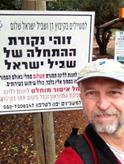
I can’t really take a month and a half out of my life to hike it all in one shot, so I’m doing it pieces. So far I’ve hiked four sections, from Tel Dan to Meron, about 40 miles. I started at the beginning – that’s where the picture was taken – and on my first outing I covered two sections, about 20 miles. Then I went home. A couple of weeks later I picked up where I left off, and hiked two more sections, another 20 miles. I’m not backpacking – I’m jogging/hiking with a day pack and sleeping in B&Bs. I hitchhike or take a taxi to get to back to my car from the start/finish. In the 40 miles I’ve covered so far I’ve seen some great scenery, met some interesting people and have had a great time. I figure it’s going to take me about a year and a half to finish the whole thing. It will get a lot trickier in the Negev, where bed and breakfast places are few and far between.
I’m going to try and post pictures and some description to this blog, with the category “Israel Trail” as I complete sections.
National Geographic Magazine has named the Israel Trail as one of the world’s 20 best hiking trails.
Here are a few resources that are really useful to anyone interested in hiking the Israel Trail:
Israel National Trail Data Project : lots of useful information, also has a forum for discussions.
Wikiloc: Digital trail maps with GPS coordinates. They have an app for iPhones which has saved my butt more than once already – the trail is not so well marked in places. Search for “Israel National Trail” or “Shevil Israel.” This is the first section.
A few equipment notes for those interested in hiking the trail:
- A smartphone with GPS and an app with a map is a REALLY good idea. My iPhone with the Wikiloc app does the job fine. Note that using the Wikiloc app really drains the battery quickly. I bought an external battery that gives me enough extra oomph to be able to finish a section without running out of battery.
- Definitely get a “shluker” or camelback-style water system. And carry some extra water or Gatorade beyond the 3 liters the shluker holds.
- In the winter be prepared for cold or wet weather…regardless of what the forecast says!
Next post will be about the hike on sections 1 and 2.
Pingback: Israel Trail Day 1 - The Neshamah Center