Israel Trail Days 29, 30, and 31
 November 13, 20, and 26, 2013
Wikiloc Maps:
Beit Guvrin to Tel Keshet
Tel Keshet to Dvira
Dvira to Meitar
Day 29 mileage: 14.8 (24km)
Day 30 mileage: 14.2 (23km)
Day 31 mileage: 14.9 (24km)
Total mileage since Tel Dan: 390 (628km)
Day 29 started at the gas station next to the Roman Amphitheater at Beit Guvrin. I’m definitely getting further away from home again – the drive is back up to an hour each way. The trail starts out briefly following Highway 35, and then turns left around the back side of the Beit Guvrin – Maresha National Park. I don’t have pictures from the National Park itself – I didn’t stop, since I’ve been there many times before. Someone hiking the trail who has NOT been there would definitely be advised to spend a few hours exploring the place, it’s fascinating. Was a hideout for rebels during the last war against Rome in the early 2nd century.
The stretch from Beit Guvrin to Lachish was pretty easy – agricultural roads past (now empty) wheat fields, a few vineyards. Gently rolling terrain. Lachish was a little further than I was expecting, about 6 miles from Beit Guvrin. The trail didn’t actually go up to the top of the tel, I took a little detour. It’s been a long time since I visited Lachish and I wanted to check it out.
They found signs of settlement at Lachish going back over 6,000 years, to the Chalcolithic Age. During the First Temple period, Lachish was the second most important city (after Jerusalem) in Judea. I also wanted to visit Lachish because when I was in London over the summer I stood in front of Sennacherib’s wall depicting the conquering of Lachish. From Wikipedia:
In 701 BC, during the revolt of king Hezekiah against Assyria, it was captured by Sennacherib despite determined resistance during theSiege of Lachish.[2] Some scholars believe that the fall of Lachish actually occurred during a second campaign in the area by Sennacherib ca. 688 BC. Nonetheless the site now contains the only remains of an Assyrian siege ramp in the Near East. Sennacherib later devoted a whole room in his South-West Palace in Nineveh for artistic representations of the siege on stone orthostats, now on display in theBritish Museum. The orthostats depict battering ramps, sappers, and other fighters along with Lachish’s architecture and its surrender, these along with the archaeology give a good understanding of siege warfare of the period.[3]
After wandering around the ruins of palace and the gate to the city I sat a picnic bench in the shade and took a break. I generally don’t eat lunch on the trail – don’t’ want to fill up my stomach. I drink Gatorade and have a granola bar and/or home made trail mix – raisins, cashews, whatever I have around home.
Leaving the archaeological site of Lachish the trail goes below the modern moshav of Lachish, going by some very extensive vineyards. The region is noted for wine. Not too far from the town, but still in the middle of nowhere, near a small grove of trees, was a marker erected in memory of one Rochman Itzik who was injured at that spot on Lag b’Omer in 1988; he died a few weeks later. I presume he was probably a teenager, and they were probably having a Lag b’Omer bonfire/party out there and he got hit by a car or something.
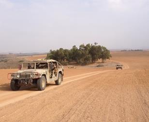
Leaving the area around Lachish, most of the rest of the day was spent on agricultural roads through barren dirt fields. I know from Diane Bradshaw’s trail blog that they grow winter wheat here, and a few months from now the area will be an ocean of green. Right now it’s just brown and dust. For some unknown reason every hour or so a convoy of IDF hummers went zooming by, raising clouds of dust. It was bad enough I had to take my contact lenses out.
About 12 miles along the trail crosses Highway 6, and shortly after crossing the highway it crosses the railroad. At this point, I missed the trail and ended up going a bit further south than I should have. Not a big deal – added some distance to the day, but less than a mile. Was a reminder how easy it is to lose the trail without GPS. One of the challenges for me on navigation for this segment and the next is that no one has yet uploaded the trail to Wikiloc, so I was having to do it the “old-fashioned” way, relying on paper maps and the trail markers. I rejoined the trail at the spot where it crosses under Highway 40 at Tel Keshet, where I was stopping for the day.
I had assumed I’d be able to call a cab or something from Tel Keshet, but it turns out there wasn’t any place there where a cab could easily get to. The highway at that point is four lane divided highway. No exit there. So I ran about another mile and a half to entrance to Ahuzam, from where I was able to get a cab. NIS 120 and about 20 minutes later I was back at the car. When I haggled over the price a little, the driver and I got into a long discussion about salaries and economics, etc. He was complaining that with the cost of gas, maintenance for the cab, etc., he has to put in a ten hour day to clear NIS 400-500 a day. But he said “but I’m not complaining…” J
For Day 30 I knew the logistics would be a little complicated because of the location of the start and finish, so my wife Lauri graciously agreed to drive me. She dropped me at the side of the road by Tel Keshet. The tel is really just a tel – not much of anything else to see there.
In his guidebook to the Israel Trail Jacob Saar recommends taking a shortcut and going south to Philip Farm and from there due south to the ruins of the Turkish railroad bridge, but I disagree with him. Yes, it’s about 8km longer, but it was the most interesting part of the day’s hike. I took the trail, and thought it was worth the 8km.
The trail starts out with the same boring barren fields as on the other side of the highway. After about two miles it crosses Wadi Shikma, there’s a grove of trees there. After Shikma the trail goes along a ridge with some nice views for about 3 miles. It then takes a left turn and heads down to Sahd Canyon They say in the spring when the flowers are blooming it’s beautiful in here – this time of year, still waiting for significant rain, it was brown. About a mile after leaving the canyon the trail goes up to the top of Tel Nagila, which has some great views. There’s a large acacia tree at the top of the tel; they say in the pre-GPS days pilots used the tree as a navigation landmark.
Tel Nagila has finds going back to the Iron Age, which is to say First Temple Period, 2500 to 3000 years ago. Leaving Tel Nagila the trail comes down to the Pura Nature Reserve. The remains of a railway bridge built by the Turks in 1915 can be seen. After the bridge the trail goes through the forest at Pura, which is pretty small. I took a break when I got to Highway 40, about 8 miles into the day’s trek. The trail parallels the highway for a fairly boring and noisy 2 miles before crossing under it. After crossing the highway the trail follows Wadi Shikma and a narrow band of pine trees for about 4 miles. Another fairly boring 4 miles – dirt road, trees on the left, open dirt fields on the right.
I missed the turn for the dirt road to the highway and had to hoof it cross country across the empty fields to get back out to the highway (3255). Thanks to the cell phones I was able to guide Lauri to where I was so she could pick me up. We drove a little further up the road to see whether it might be feasible for me to rely on my bicycle to get back to the car after the next leg, but decided not – very narrow shoulders with huge trucks barreling down the road. Didn’t look like a good place to bike. I’ll have to figure out some other logistical arrangement for day 31. All in all, day 30 was one of the more boring days on the trail, but I made good time and I’m 15 miles closer to Eilat.
For Day 31, I figured out a different way to get back to my car – called a “trail angel” who agreed to give me a ride. So I just drove myself to where I left off last week, and was out on the trail by 8:45. The first few miles were similar to the last few miles of day 30, fields on one side, trees on the other. The trail loops behind Kibbutz Dvira. Three miles in I came to Dvir Forest, which was small, but the shade was welcome – it was a hot day, about 93F (34C) and very windy. There were some ruins of an ancient cave dwelling in the forest.
About four miles in, the trail made a left on 3255, and followed it for about a mile. Lots of huge trucks barreling past at high speed – I assume there must be a quarry up in the hills. The trail then takes a right turn and goes up “Ga’at Hill,” in the Lahav Nature Preserve. Very desert-like topography – reminded me a lot of New Mexico or something. No shade, 90+ degrees, up a steep hill. Not the most fun. After another mile and a half, 6.5 miles in, I came into Lahav Forest, which was at least shady. The JNF started planting the forest in 1952. It’s sort of amazing that they could plant a forest in the Negev, I wouldn’t have thought there’s enough rain. At the top of the hill in the forest is the Joe Alon Center and Bedouin Heritage Museum. I stopped and explored the museum, it’s a worthwhile stop. Learned interesting about the Bedouin, including that they had a “trial by ordeal,” that involved putting your tongue on a hot pan three times to determine guilt/innocence. If your tongue gets burnt, you’re guilty. If you’re there at the right time of day you can also hang out in the Bedouin tent and drink tea…something I’ve had the chance to do with real Bedouins, not just in a museum. After taking a break in the shade at the cafeteria I was back out on the trail. It was also a convenient spot to refill my water.
The trail works its way around Kibbutz Lahav and crosses road 358. From here the trail goes right up against the “security barrier” that divides Israel from Palestine/West Bank. In this area the barrier runs right along the “Green Line,” the old border between Israel and Jordan between ’48 and ’67; in other places the barrier cuts significantly into the West Bank. For most of its length the barrier is a series of three fences and a paved route, with motion detectors, barbed wire, etc. Apparently other border areas, such as the California – Mexico border and the India-Pakistan border have been interested in the Israeli approach. It is a pity that the barrier is for now a “necessary evil.” It does seem to have contributed to a reduction in terror attacks in Israel.
Leaving the security barrier the trail went up through a forest near Sansana. Sansana is an interesting little community because it straddles the Green Line – so part of it is in Israel proper, and part is considered by the international community to be a “settlement.” I really don’t understand why the Israeli government is being so obstinate about land – insisting on continuing to build settlements in the West Bank, evicting Bedouins from their lands in the Negev. There really is no shortage of land here, both in the Negev and in the Galilee. I can say that with some confidence having run past LOTS of vacant land. <sigh>
Leaving Sansara it was more barren terrain until crossing highway 60, the main highway that runs up the spine of the Judean Hills in the West Bank and arriving at the community of Meitar. Took me about four and half hours to run my 24km today.
There are people who offer to help out people hiking the Israel Trail called “trail angels.” As the logistics are getting more complicated, I thought I’d call one. He picked me up and I hung out in the shade in his backyard until he was ready to leave. It really was a huge help – cabs way out there would have been very expensive. And I met an interesting person – a holistic healer who does massage and psychodrama among other things. Another interesting day on the trail.
“November 13, 20, and 26, 2013
Wikiloc Maps: http://www.wikiloc.com/wikiloc/view.do?id=5624050
http://www.wikiloc.com/wikiloc/view.do?id=5657766
http://www.wikiloc.com/wikiloc/view.do?id=5689666”
From Israel Trail Day 29, 30, 31 Beit Guvrin to Meitar. Posted by Barry Leff on 11/14/2013 (138 items)


- At the start of Day 29 on the Israel Trail


- The trail starts at Beit Guvrin, for a brief stretch along highway 38


- Not much shade at all today.


- In the area around Lachish, which is known for wine.


- Note the Israel Trail marker on the pipe


- Tel Lachish; Lachish was the 2nd most important city in Judea 2,700 years ago.


- Look closely and you can see the pigeons roosting


- Several times during the course of the day I was passed by convoys of IDF jeeps zippi…


- "In memory of Rochman Itzik of blessed memory, who was injured in the place on t…


- These endless barren fields apparently are sown with winter wheat; they say it is ver…


- Highway 6


- Crossing Highway 6; I made a wrong turn just past the highway which probably added 1-…


- Crossing Highway 40 at the end of the day's hike. I was disappointed that there…


- At the finish for Day 29 at Tel Keshet


- Not a very promising start…


- Crossing Wadi Shikma — a bit of green in the midst of the barren fields.


- This turnoff was not well marked (the trail is some distance above). Could easily ha…


- Archaeologists have found stuff 6,500 years old at this tel. The acacia supposedly w…


- Remains of a railroad bridge built by the Turks in 1915.


- Not so nice when the trail goes past a pile of garbage.


- Highway 40


- The scenery was more or less exactly like this for 7km — dirt road next to a thin st…


- At the end of Day 30. Near the Bedouin town of Rahat, about 15 miles north of Beersh…


- At the start of Day 31 on the trail, near Kibbutz Dvira


- The day started out the same way the last day ended … agricultural road next to a r…


- These are caves that were turned into dwelling places. There are still a few hundred…


- Road 3255. The trail goes along the road for a ways. There was a pretty steady strea…


- I didn't hike up to the top of the ruins, the description didn't sound like…


- Ga'at Hill in the Lahav Nature Reserve. Looks a lot like the American Southwest…


- Lahav Forest


- The Joe Alon Center and Bedouin Heritage Museum in Lahav Forest. I spent about half …


- The Bedouin had (have?) a form of "trial by ordeal," see "Licking Fire…


- Crossing Road 358


- The "security barrier" between Israel and the West Bank in the background. …


- "Mortal Danger"


- Highway 60 — Hebron to the north, Beersheva to the south.


- Metar is surprisingly upscale for a place in the middle of nowhere.


- I got a ride back to my car from a "trail angel." He had a very cute dog.

Generated by Facebook Photo Fetcher 2
(Israel Trail Day 29, 30, 31 Beit Guvrin to Meitar)