Israel Trail Day 52 (Final Day) Netafim to Eilat
December 25, 2014
Wikiloc Map: Netafim to Eilat
Distance: 18.1 km
Total distance since Tel Dan: 1127km (699 miles)
This was my final day on the Israel Trail. I kept finding it hard to believe that I was actually finishing. The trail has been such a big part of my life for the last nearly two years – it will be strange being “done.”
My wife Lauri, and two of my daughters, Katherine and Devorah, and a friend, Charlie, and I drove down to Eilat Wednesday night and stayed in a place from Airbnb. We stopped at Kibbutz Ketura on the way down for dinner and to visit with some friends from Jerusalem who were staying down there.
Thursday morning we got everyone up about 0630, had breakfast, and headed to the trailhead where we were meeting another friend, Jodi. Lauri was our “driver.” The others joined me on the trail, which was great fun for me – I felt like I had a little “honor guard” accompanying me on the last day on the trail.
Our group of five got out on the trail at about 0830. There was a fairly large group, maybe 15 hikers, that left about 15 minutes before we did. We came across several other groups of hikers on the trail as well – this is clearly a popular section of the trail. I think Nahal Amud in the Galilee is the only other section where I saw as many hikers.
Quick summary: the day was harder and longer than I expected. The guidebook said 14km; it was actually 18. The guidebook said it would be an easy day compared with the preceding day – it wasn’t. But it was a very nice day, rugged terrain and great views.
We started by getting lost, which is perhaps not the most auspicious beginning to our day, and it didn’t do much to highlight the great experience I had acquired as a guide after nearly two months’ worth of running and hiking on the trail. We followed the direction where the trail marker pointed. My guidebook said follow the blue trail but we could see no sign whatsoever of a blue trail. All we saw was a black trail. While Google Maps shows the Israel Trail in some sections, this was not one of them. So the GPS wasn’t a great help at this point.
I decided we’d go “cross-country” to try and find the start of the blue trail. After less than a kilometer, from looking at the map I thought it looked like we should be closer to the border with Egypt, so we took a right turn “cross-country” and headed for the wadi. Once we got down into Wadi Gishron we saw trail markers – for the black trail. Still no blue trail, and no Israel Trail markers. But it was going in the right direction, so I decided we’d follow it.
After about an hour of hiking we were at the 2.5km mark. There were some spectacular views of a ravine far below with a road and fence marking the border with Egypt. It’s one of those roads you look at in wonder, saying “how did they ever build that?” Unfortunately it’s just for military use. I hope the soldiers enjoy what must be a spectacular view of large granite mountains on either side.
It was also where our trail joined with the blue trail coming in from the northeast – and with the blue trail, we had the tri-color Israel Trail marker, confirming we were now for sure on the right path. It looks like we might have had about a half kilometer detour following the wadi instead coming more directly from the parking lot. We also came across a religious couple who were doing a 3-day hike; they found something on the trail, but it wasn’t ours. We took their contact info to give to the big group of hikers in case it was something that belonged to one of them.
From here we had a long steady descent of about five kilometers. Mount Yoash on our left side, Egypt on our right side. I also discovered one of the benefits of having a kid along – at one point Devorah (age 13) decided to check for an echo. There was a large granite cliff directly across from us, probably no more than a kilometer away, and sure enough there was a GREAT echo. We all had fun playing with it for a while. If it hadn’t been for Devorah we probably never would have discovered it.
Parts of the descent were rugged, and in a few spots there were ladders, railings, or handholds to assist our way. It also became clear that kids (Katherine at 18 was keeping up with Devorah) were bounding along ahead of us with great energy. Devorah was like a mountain goat. Even though as a runner I could have kept up with them, I decided I’d take it easy today and hang back with the grownups.
Along the way we passed a family that was hiking – with the dad carrying a baby in a backpack. We caught up with them at a rugged spot, and we were all thinking “I wouldn’t want to do that with a baby on my back…” We also wondered if they knew how rugged this section of the trail was going to be before they headed. Very likely could have since they seemed to have fairly serious hiking gear – an indicator that they know what they’re doing.
Just before noon, after 8km of hiking, we reached the Gishron Ascent, our first ascent of the day. It was short – only about a half a kilometer – but it climbs 100m (300 feet) in that distance, so it’s pretty steep. We also added a little climbing and distance by missing a trail marker and going up a dead end box canyon.
We had some great from views from top. We then found ourselves walking along a very narrow ridge with a sheer drop off on our right side. After perhaps a kilometer of walking along the ridge we came to what apparently was an abandoned IDF observation point overlooking the border with Egypt. It was probably abandoned quite some time ago – there was the metal frame of a bus seat there that the soldiers presumably used as a sofa, but any padding or covering was gone.
We were wondering how far the soldiers had to hike to get to this point; our question was answered pretty quickly: only a few hundred meters. We crossed a paved road, and were somewhat amused that the trail marker indicated we should just keep going right past a large sign that said “Stop! Border Ahead! Crossing is prohibited! Trespassing or touching the fence endangers your life!” Bold explorers we, continued on our way, fortunately not close to any fences. We crossed the road at 1240pm, with about 10.5km behind us. It was clear that the hike was going to take longer than I initially thought – and I didn’t even yet know that it was going to be 4km longer than “advertised.”
From here the Israel Trail joined a red trail going down to Wadi Tsfahot. By now, I had figured from looking at the map that we were going to be doing 3 or 4 km more than 14…we hit 14 about the time we got down to the Wadi. And in the usual way the trail works, what does down must go up. We had one more climb to the top of Mt. Tzfahot. We got to the top of the mountain about 2:30 and were treated to an awesome four-country view – Israel, Jordan, Egypt, and Saudi Arabia. A lot of people aren’t aware of how close Israel is to Saudi Arabia at this point – only about 20 miles away.
From here all that was left was a pretty easy two kilometer descent to the beach. About a kilometer from the end we were “ambushed” by a group of kids bearing water guns. Lauri and another friend, Yosef, met us with Jodi’s kids and some of Yosef’s kids. The “ambush” was a lot of fun. The only bad thing is they had so much fun have a water gun fight while waiting for our delayed arrival that they didn’t have much “ammunition” left to spray us with. They said they were out “Barry hunting!” J
We got down to Coral Beach. I had always pictured finishing the trail with some kind of spectacular jump into the ocean. But the air temperature was actually pretty chilly, and water felt quite cold, so I settled for going in and getting my feet wet. I didn’t want to be wet and cold for eating lunch.
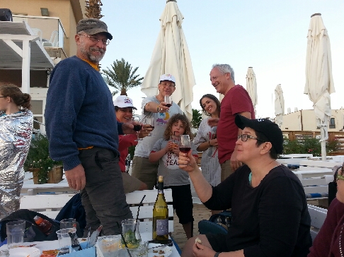
It was about 315 when we got to the beach and retired to nearby restaurant for a well deserved lunch break. For a final bit of fun, a hiker I met on the trail, Aryeh, who is friends with several people from our group, showed up with a bottle of wine.
I felt very honored by the group of friends and family who came along with me on this last section of my Israel Trail journey. It really was an amazing experience to cover the entire country on my own two feet. I feel so much of a deeper connection to the land now, and know so much more of what’s here. One of the best things I’ve ever done – fun, healthy, educational. A great combination. I plan to write one more blog post about the trail with my thoughts on which sections are the “highlights” for people who don’t have time to do the whole trail.
From Israel Trail – 52nd (and final!) Day, Netafim to Eilat. Posted by Barry Leff on 12/26/2014 (67 items)

- At the start of my 52nd (and last) day on the Israel Trail, with my "honor guard…


- If you look closely you can see a road down in that gash — the border between Israel…


- The trail came down that cliff face


- This was an abandoned IDF post overlooking the Egyptian border. The metal contraptio…


- Love the way the trail marker goes right past the sign warning that continuing endang…


- Four-country view — Israel, Jordan, Saudi Arabia, and Egypt


- Yosef and an assortment of kids "ambushed" us with water guns on the way do…


- I did it! Finished the entire Israel Trail from Lebanon to Egypt!


- "ambushed" at the end


Generated by Facebook Photo Fetcher 2
(Israel Trail – 52nd (and final!) Day, Netafim to Eilat; 67 photos)